

1. Define the acquisition decision
The first decision is whether the buyer can price, contract and finance a renewable platform whose assets are physically dispersed and whose evidence quality differs by project. Southeast Asia has rising electricity demand, large renewable ambitions and material financing needs. The International Energy Agency reports that annual regional energy investment exceeded USD 100 billion in 2025, while grid investment continued to lag generation needs [1]. The opportunity is substantial, but a regional label does not create a common operating environment. Each asset depends on its own land rights, permits, interconnection, offtake, equipment, construction record and local operating capability.
The acquisition perimeter should therefore be an asset-level register rather than a portfolio total. The register should identify legal entity, site coordinates, technology, capacity, development status, commercial-operation status, land instrument, interconnection point, offtake arrangement, lender, insurer, operator, key contractor and data owner. Every line in the valuation model should reconcile to this register. A project that cannot be matched to a legal entity, physical site and contractual cash-flow right should remain outside the base case until the mismatch is resolved.
Satellite diligence supports this decision by creating an independent physical chronology. It can test whether reported site activity is visible, whether the developed footprint is broadly consistent with claimed capacity, and whether material changes occurred before or after a stated milestone. It cannot replace the legal, technical, financial, environmental or tax workstreams. The investment committee should use it as a disciplined source of exceptions and follow-up questions.
| Stage | Satellite or geospatial evidence | Required corroboration | Transaction consequence |
|---|---|---|---|
| Screen | Site location, land cover, visible access and development footprint | Asset register, cadastral plan and permit map | Include in diligence universe |
| Validate | Multi-date construction and operating observations | Engineer report, invoices, energisation and meter records | Confirm milestone or create exception |
| Underwrite | Weather, hazard, curtailment and production reconciliation | SCADA, grid notices, PPA and operating accounts | Adjust cash flow and risk case |
| Contract | Evidence-backed unresolved issue | Seller disclosure, warranty, indemnity, escrow or condition | Allocate or retain risk |
| Monitor | Post-close change detection and operating exceptions | Field inspection, operator report and financial ledger | Trigger remediation or integration action |
Remote observations become transaction evidence only after defined corroboration.
2. Use satellite data as a diligence instrument
Satellite data has three useful roles in an acquisition. First, it can screen a large portfolio quickly and identify sites that deserve deeper work. Second, it can create a consistent historical record where the seller's documents have different dates, naming conventions or levels of completeness. Third, it can support post-close monitoring by applying the same observation logic to the acquired estate. These roles are strongest when imagery is linked to a defined decision and a named evidence owner.
Sentinel-2 provides multispectral observations with bands at 10-metre resolution and a designed five-day revisit at the Equator [11,12]. This can support broad land-cover and visible-construction analysis, subject to cloud, atmospheric effects, shadows, seasonal vegetation and the size of the feature. Sentinel-1 radar can observe through cloud and darkness and can support change and deformation analysis through interferometric methods [13]. Landsat provides a long global archive that supports change analysis over decades [14,15]. Commercial imagery may offer finer spatial or temporal resolution, but the licence, collection conditions, archive depth and evidential reproducibility must be recorded.
Resolution is not the same as certainty. A solar array may be visible without proving module specification, electrical completion or grid export. A cleared area may indicate construction, agriculture, quarrying or another activity. A road may exist but remain legally inaccessible. The diligence system should record what was observed, what interpretation was made, what alternative explanations remain and what corroboration is required.
3. Freeze the asset universe and legal perimeter
Platform transactions can change during diligence. Projects may be added, excluded, substituted or transferred between special-purpose vehicles. Coordinates may identify a development area rather than the final leased parcel. One project name may refer to several phases, while several project names may share one grid connection. The buyer should freeze a version-controlled acquisition perimeter before remote analysis begins.
The perimeter register should contain polygon boundaries rather than only points wherever reliable boundaries exist. It should distinguish owned land, leased land, easements, access routes, transmission corridors, temporary construction areas and shared facilities. It should also record the source and date of each geometry. Seller-provided polygons, cadastral plans, environmental maps and engineering drawings may disagree. The disagreement is itself a diligence finding.
Every site should have a unique transaction identifier that survives name changes. Subsidiary ownership, permits, contracts and financial results should be mapped to that identifier. Shared infrastructure requires an allocation rule and a legal-rights review. The platform valuation should not count capacity, land or cash flows twice merely because the same physical component appears in more than one schedule. A signed closing perimeter should ultimately reconcile to the disclosure letter, share-purchase agreement and funds flow.
4. Build a source and lineage register
Every image, map layer and derived feature should enter a source register. The register should state provider, product, acquisition date, processing level, resolution, coordinate reference system, cloud or quality mask, licence, transformation steps and analyst. For algorithmic outputs, it should also record the model version, training data boundary, threshold, confidence score and validation result. This allows another reviewer to reproduce the finding and understand its limitations.
The source register should separate public data, seller data, buyer-commissioned data and licensed commercial data. Public availability does not remove licence obligations or accuracy limitations. Seller data may be contractually confidential and may contain personal or sensitive operational information. Commercial data may restrict redistribution, derivative products or use after the licence period. The transaction team needs a lawful basis and a retention rule for each dataset.
Model lineage matters because an acquisition decision can outlast the diligence team. If the buyer later relies on the same score for integration, insurance or financing, it must know whether the underlying data remained current. A feature generated from cloud-obscured imagery should not silently become a permanent asset attribute. The register should identify observations that expire, require refresh or need field validation before closing.
5. Establish a time-stamped physical baseline
A useful baseline begins before the seller's claimed construction start and continues through the latest available observation. The chronology should include planning, land preparation, access works, foundation activity, equipment installation, apparent completion and visible subsequent change. Seasonal comparisons should use like-for-like periods where vegetation, flooding or agricultural cycles could produce false signals.
The World Bank's solar mapping work distinguishes resource mapping from ground measurement and uses field stations to validate satellite-derived estimates [16,17]. The same principle applies to acquisition diligence. Remote observations create hypotheses, while ground records establish the commercial fact. The baseline should therefore be aligned with dated engineering certificates, contractor invoices, grid-acceptance documents, meter commissioning and asset photographs. A visible array before the claimed completion date may support the chronology, but electrical completion still requires documentary and technical evidence.
The baseline should preserve negative findings. If imagery is missing, cloud-obscured or too coarse to resolve a question, the record should state that the point could not be observed. An absence of visible change does not prove inactivity. A buyer gains more from a precise statement of evidential limits than from a forced conclusion.
6. Verify construction progress by milestone
Construction progress should be decomposed into observable and non-observable milestones. Observable work may include clearing, roads, foundations, tracker rows, module fields, turbine pads, crane activity, substations and transmission corridors. Non-observable work may include cable termination, relay protection, software configuration, equipment testing, punch-list closure and grid-code compliance. Each milestone should have an accepted evidence combination.
The analyst should compare the physical chronology with the engineering schedule and drawdown history. A reported 80-percent completion figure is not decision-ready unless the buyer understands whether it represents cost incurred, equipment delivered, work certified, generation capability or remaining critical path. Satellite-derived area completion can be misleading when high-value electrical and grid work remains outstanding.
For construction-stage acquisitions, milestone exceptions should flow into remaining capital, delay damages, contingency and closing conditions. A delayed substation or export line may have greater value impact than incomplete module installation. The buyer should require an independent engineer to resolve material exceptions and should avoid using remote evidence as a substitute for safety inspection or commissioning.
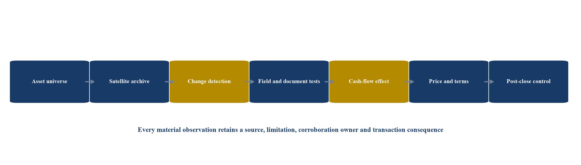
Proposed control sequence. Imagery creates an observation; corroborating evidence determines whether it changes price, terms or post-close control.
7. Test land use without treating pixels as title
Land is a frequent source of renewable-project delay and dispute. Satellite imagery can show occupation, cultivation, settlements, roads, water bodies, forest cover and change over time. It cannot establish legal ownership, valid lease execution, consent, compensation, customary rights, easement priority or compliance with land-use restrictions. The buyer should treat visible land use as a prompt for legal and social diligence.
IFC guidance treats land acquisition and livelihood restoration as a continuing process involving baseline data, stakeholder engagement, implementation and monitoring [19]. The IFC Performance Standards also address biodiversity, ecosystem services, Indigenous Peoples, labour, community health and cultural heritage [18]. A map of apparently empty land does not prove the absence of seasonal users, informal rights, cultural significance or ecosystem dependence.
The land workstream should reconcile project polygons with executed instruments, cadastral evidence, payment records, access rights and grievance logs. Visible encroachment or nearby settlement growth should trigger site-specific inquiry. Where boundaries or rights remain contested, the buyer should quantify schedule, compensation, redesign and litigation exposure and allocate the issue through closing conditions, escrow or exclusion.
8. Reconcile grid connection and export infrastructure
Grid access is central to renewable value. Satellite observations can confirm the visible presence of substations, lines, roads and major construction. They cannot prove reserved capacity, completed protection studies, energisation, dispatch rights, metering acceptance or payment entitlement. The buyer should reconcile physical infrastructure with the interconnection agreement, grid studies, commissioning records, curtailment notices and settlement data.
Southeast Asia's grid needs are material. The IEA expects rapid electricity-demand growth and highlights expanding networks and regional interconnection as essential to integrate renewables [1,4]. National plans can change the timing and priority of generation and transmission projects. Indonesia's 2025-2034 electricity plan contemplates 69.5 GW of added generation, with 76 percent attributed to new and renewable energy [21]. Viet Nam continues to implement and update its power-development plan [22]. Portfolio diligence should therefore use current country evidence rather than assuming that visible proximity to a line creates connection certainty.
A project with completed generation equipment but delayed export infrastructure may require additional working capital and debt-service relief. The acquisition model should separate mechanical completion, energisation, commercial operation and reliable dispatch. Each date should have its own evidence and valuation consequence.
9. Validate permits, incentives and revenue rights
Renewable cash flows depend on instruments that imagery cannot authenticate. These include generation licences, environmental approvals, land-use conversion, grid connection, auction awards, feed-in tariff eligibility, renewable certificates, tax incentives and power-purchase agreements. The buyer should create a permit and revenue-rights matrix by asset, issuing authority, holder, capacity, term, milestone, transfer requirement and consequence of breach.
The Philippines announced a 10-year Green Energy Auction programme targeting at least 25 GW of additional renewable capacity through 2035 [20]. Malaysia operates several mechanisms, including feed-in tariff processes and net-energy-metering programmes with technical-study and commissioning requirements [23,24]. These examples show why a regional portfolio cannot be diligenced through one generic checklist. Programme rules, award conditions and change-of-control requirements differ.
Satellite evidence can test whether physical development occurred within the permitted area and by the required milestone. It cannot prove that the holder complied with every award condition or retained the revenue entitlement after a corporate reorganisation. Legal confirmation and direct authority evidence remain necessary. Any incentive that cannot be tied to the acquired entity, site, capacity and operating status should be excluded from the base case until resolved.
10. Assess operating condition with appropriate limits
Operating assets may look complete while suffering equipment failure, vegetation shading, drainage problems, erosion, access constraints or incomplete remediation. Multispectral and radar observations can identify selected surface changes and recurring patterns. They cannot diagnose inverter faults, blade damage, transformer condition, protection settings or contractual maintenance quality without supporting data and inspection.
The operating review should combine remote observations with SCADA, meter data, work orders, alarm logs, spare-parts records, warranty claims and maintenance invoices. A visible change should be mapped to the operating record. If a portion of a solar field appears disturbed, the buyer should ask whether modules were removed, replaced, damaged or merely obscured. If standing water appears near equipment, the buyer should examine drainage design, flooding history, insurance and remediation.
Field sampling should be risk-based. Sites with weak data, unusual production variance, material climate exposure, ownership complexity or visual anomalies deserve deeper inspection. The sample should also include apparently clean sites to test whether the model systematically misses issues. Satellite scoring should guide effort rather than replace engineering judgement.
11. Rebuild the production bridge
Reported generation should be decomposed into resource, availability, curtailment, grid outage, degradation, soiling, clipping, auxiliary consumption, meter adjustments and data gaps. A platform-level variance hides site-specific causes and can misprice operating quality. The buyer should rebuild the bridge for each material asset and then aggregate on a consistent basis.
Weather-normalised expected generation should use documented resource data and model assumptions. Satellite-derived irradiance or wind products may support this analysis, but the buyer should understand resolution, bias correction, uncertainty and ground validation. Actual generation should reconcile to revenue meters and settlements, not only to operator dashboards. Lost-energy classifications should reconcile to grid notices, work orders and contractual compensation.
The acquisition model should distinguish recoverable from structural underperformance. A maintenance backlog may be cured with defined capital and downtime. Persistent resource overstatement or grid constraint may require a permanent haircut. The seller's forecast should be preserved as submitted, while the buyer builds a separate evidence-based case and a downside case.
| Variance driver | Remote indication | Required operating evidence | Valuation treatment |
|---|---|---|---|
| Weather | Resource anomaly relative to baseline | Ground station and validated resource series | Normalise forecast with uncertainty |
| Availability | Visible disturbance or inconsistent operating pattern | SCADA alarms, work orders and meter intervals | Apply outage and repair case |
| Curtailment | No reliable visual proof | Grid dispatch and settlement notices | Model compensated and uncompensated loss |
| Degradation | Long-run output decline may be consistent with several causes | Module tests, warranty data and engineering analysis | Adjust yield and repowering capital |
| Data quality | Missing or conflicting timestamps | Meter hierarchy, audit trail and reconciliations | Reduce confidence and defer value |
Each variance classification requires operating evidence before it changes cash flow.
12. Separate weather from operational performance
A short production history can be dominated by unusual weather. A buyer should establish a resource baseline, compare multiple data providers, and reconcile the seller's methodology to observed site conditions. Where satellite-derived resource data is used, modelled values should be compared with calibrated ground instruments or accepted independent-engineer methods. The objective is a range of expected production with stated uncertainty.
Weather-normalisation should not absorb every unexplained shortfall. A model can mechanically attribute weak production to low irradiance or wind when the real causes include availability, soiling, clipping, wake effects or curtailment. The bridge should preserve residual variance and assign an investigation owner. Repeated residuals may indicate a structural model or equipment problem.
Climate trends can also alter the relevance of historical averages. The buyer should assess whether temperature, rainfall, storm, smoke, drought or wind-pattern changes affect future generation or operating cost. The appropriate response is scenario analysis supported by authoritative data, rather than a single deterministic adjustment. Investment committees should see the relationship between resource uncertainty, operating evidence and valuation.
13. Identify curtailment and dispatch constraints
Curtailment is often economically material and is poorly suited to visual inference. An asset can appear complete and available while the grid restricts export. The buyer should obtain dispatch instructions, meter intervals, grid-outage records, compensation calculations, PPA provisions and correspondence with the system operator. Data should be aligned to a common time zone and reconciled to billed revenue.
The distinction between deemed generation, compensated curtailment, uncompensated curtailment and plant unavailability is crucial. Contract definitions may differ from operational classifications. A seller may report technical availability while revenue remains constrained. The buyer's model should follow the contractual cash consequence rather than a dashboard label.
Portfolio acquisitions also require correlation analysis. Grid constraints, hydrology, storms or policy actions can affect several assets together. Diversification credit should be earned through evidence of different nodes, weather regimes, technologies, counterparties and contractual protections. Geographic dispersion alone does not prove economic diversification.
14. Evaluate degradation and repowering
Solar modules, inverters, batteries, turbines and balance-of-plant components have different degradation, failure and replacement patterns. Satellite imagery may reveal layout, visible replacement or land available for expansion. It does not establish nameplate specification, serial number, warranty coverage, remaining useful life or replacement compatibility. The buyer needs the equipment register, commissioning dates, tests, failure history, warranty claims and spare-parts strategy.
Repowering value should be treated separately from the current operating case. A site may have grid, land and offtake rights that support additional capacity, but the buyer must confirm technical, legal and commercial headroom. Module replacement can change DC loading, protection, permits and warranty interactions. Turbine replacement can require foundation, crane, transport and grid studies.
The valuation should show the capital, outage, approval and revenue assumptions for each repowering option. Optionality has value only when the rights, physical capacity and economics are evidenced. A map of unused land is an invitation to investigate, not an asset in the base case.
15. Quantify climate and natural-hazard exposure
Southeast Asian assets can face typhoon, flood, landslide, wildfire, heat, drought, volcanic, seismic and coastal hazards. Hazard layers should be screened at asset and shared-infrastructure level. The buyer should distinguish hazard from vulnerability and exposure. A site may lie in a hazard zone yet have resilient design, while a low-frequency event can still create severe value loss through a vulnerable grid connection or access route.
Remote observations can support flood extent, shoreline change, burn scars, vegetation stress and ground movement. Sentinel-1 radar is particularly useful where cloud limits optical data, while interferometric analysis can reveal certain deformation patterns [13]. These outputs require specialist interpretation, and vegetation or geometry may reduce precision. Engineering review, design standards, elevation data, maintenance and event history remain essential.
The acquisition model should connect hazards to downtime, repair capital, deductibles, premium, exclusions, business interruption and debt-service resilience. Insurance should be reviewed by site and peril. A policy that covers physical damage may not cover grid outage, access loss or revenue interruption on expected terms. Climate assumptions should be explicit and should not be hidden in a generic discount-rate premium.
16. Integrate environmental and social diligence
Environmental and social diligence should be embedded in the acquisition model and transaction timetable. Satellite data can screen land-cover change, proximity to settlements, protected areas, waterways and selected habitat features. It cannot determine consent, grievance quality, labour conditions, cultural heritage, species presence or legal compliance. A site that appears physically contained may still have off-site access, livelihood or cumulative impacts.
The buyer should reconcile environmental and social impact assessments, permits, management plans, monitoring reports, complaints, compensation records and lender requirements. Material gaps should have cost, timing, responsibility and remedy. IFC Performance Standards provide widely used principles for managing environmental and social risks, including land acquisition and biodiversity [18,19]. Local law and project-specific finance documents remain controlling for the transaction.
An acquisition can inherit historical issues even when the buyer did not cause them. The diligence plan should identify legacy land acquisition, compensation, habitat clearance, contractor conduct and community commitments. Seller warranties and indemnities should reflect the evidence, while the integration plan should assign accountable owners and reporting.
17. Build the portfolio concentration map
A renewable platform can appear diversified while concentrating risk in one grid, offtaker, contractor, technology, permit regime, data system or climate corridor. The buyer should map dependencies at asset and portfolio level. Coordinates can reveal physical clustering; contracts and operating data reveal economic clustering.
The concentration map should cover country, currency, offtaker, tariff mechanism, grid node, equipment vendor, operator, insurer, contractor, weather regime, hazard, land tenure and debt structure. It should identify shared facilities whose failure affects multiple projects. Correlation assumptions should be tested against historical events and contractual terms.
Investment decisions should distinguish diversification of nameplate capacity from diversification of cash flow. Ten sites under one auction, connected to one constrained region and serviced by one contractor may behave like one exposure. The model should apply portfolio downside cases that combine correlated events rather than merely summing isolated site cases.
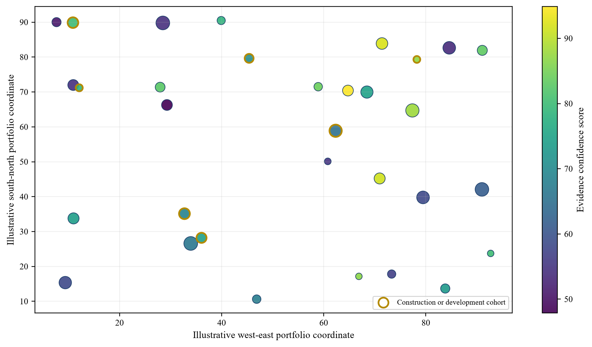
Abstract coordinates do not represent real locations. Marker shape indicates stage; colour shows evidence confidence; size shows management-assumed capacity.
18. Localise regulation and market design
Southeast Asia is not a single power market. Countries differ in utility structure, auctions, tariffs, corporate power arrangements, renewable certificates, foreign ownership, land tenure, tax, currency controls and change-of-control processes. The ASEAN Taxonomy provides a regional reference framework, while national rules and taxonomies remain relevant [7,8]. A platform buyer needs a country schedule attached to the common diligence framework.
The Philippines' auction expansion, Indonesia's electricity plan, Viet Nam's power-development process and Malaysia's renewable programmes illustrate different routes to market [20-24]. The buyer should verify the current rule, award, implementation guidance and authority for each asset. Policy announcements should not be treated as bankable revenue.
Regulatory-change scenarios should show the affected asset, contract protection, pass-through, mitigation and valuation. Foreign investment approvals, licence transfers and merger control should enter the closing timetable. Local counsel should confirm enforceability and transfer mechanics. The platform model should not aggregate revenue across countries until these differences are reflected.
19. Construct the hypothetical acquisition case
The illustrative platform contains 32 solar and onshore-wind assets across Indonesia, the Philippines, Viet Nam and Malaysia. Management assumptions include 420 MW of gross capacity, 25 operating assets, five assets under construction and two late-stage development assets. The seller presents data-room EBITDA of USD 32 million and a headline enterprise value of USD 310 million. These figures are designed solely to demonstrate the framework.
The buyer's evidence review tests every asset against the frozen perimeter, physical chronology, land rights, grid status, permits, revenue contracts, production bridge, climate exposure and environmental obligations. Each finding receives an evidence grade: verified, partially verified, unresolved or contradicted. The grade does not mechanically determine value; it controls the next action and the confidence assigned to cash flow.
The illustrative analysis produces downward adjustments for unverified construction milestones, land and interconnection gaps, production and curtailment differences, and climate and insurance exposure. It also identifies repowering value where rights and grid headroom appear supportable. No single satellite observation produces a valuation adjustment. Each adjustment requires reconciliation with transaction evidence and an approved modelling assumption.
| Cohort | Assets | Capacity MW | Evidence position | Required action |
|---|---|---|---|---|
| Operating and reconciled | 18 | 255 | Physical, contractual and meter evidence substantially aligned | Underwrite base case |
| Operating with exceptions | 7 | 85 | Production, curtailment or land evidence incomplete | Apply asset-specific downside |
| Under construction | 5 | 65 | Visible progress differs from stated milestone at selected sites | Independent engineer and capex holdback |
| Late-stage development | 2 | 15 | Site and permit evidence exists; revenue and grid rights remain conditional | Exclude from funded base case |
| Total | 32 | 420 | Management assumptions | Reconcile before approval |
All locations, capacities and evidence positions are management assumptions created to demonstrate the framework.
20. Score evidence rather than appearances
An asset scorecard should separate dimensions instead of compressing them into one opaque number. Recommended dimensions include perimeter identity, physical chronology, land, permitting, grid, revenue contract, construction, operating data, environmental and social compliance, climate, insurance and data lineage. Each dimension should show evidence status, materiality, owner and next action.
Weights may guide workflow, but the score should not override a fundamental failure. A missing transfer consent, invalid land right or absent grid entitlement can remain a reject condition even when other evidence is strong. The scorecard should therefore include hard gates and explainable judgement.
Confidence should be attached to evidence, not to the attractiveness of the asset. A high-confidence adverse finding is different from a low-confidence positive inference. The investment committee should see both. Exceptions should link directly to the model, contract mark-up and integration plan so that the scorecard becomes a decision instrument rather than a presentation layer.
21. Run a phased diligence process
The first ten days should freeze the perimeter, load source data, establish the image archive and identify fatal gaps. The buyer should rank sites by value, uncertainty and risk correlation. Early work should focus on matters that can change bid strategy, exclusivity or resource allocation.
Days eleven to thirty should reconcile construction, land, grid, permits, production and climate evidence. Fieldwork should target exceptions and a control sample. Legal, technical, financial and environmental teams should use one issue register with common asset identifiers. Every issue should have an evidence request, deadline, owner and transaction consequence.
Days thirty-one to sixty should close high-value gaps, finalise the buyer case, negotiate protections and design post-close controls. Findings that cannot be resolved should become price adjustments, deferred consideration, escrow, warranty, indemnity, condition, covenant or exclusion. The diligence team should not leave material uncertainty in narrative form when it can be allocated through the transaction.
22. Convert findings into transaction structure
The form of consideration should reflect the evidence. Verified operating assets may support cash consideration at closing. Construction-stage assets may require milestone-based payment, capex holdback or independent-engineer certification. Development assets may require contingent value linked to land, permit, grid or offtake milestones. Unresolved historical liabilities may require escrow or indemnity.
The buyer should distinguish uncertainty that can be cured from risk that should remain with the seller. A missing document may be curable before closing. A disputed land right or structurally constrained grid node may require repricing or exclusion. The mechanism should be measurable, time-bound and enforceable.
Financing should follow the same evidence boundary. Lenders may exclude construction or development cohorts, require reserves, limit distributions or impose asset-level covenants. The equity case should account for trapped cash, security packages, change-of-control consents and refinancing. A platform price that assumes unrestricted cash movement can overstate value.
23. Draft warranties, indemnities and conditions from evidence
Transaction documents should use findings that can be defined and tested. Capacity, location, permit status, commercial-operation date, land instrument, grid entitlement, PPA, meter data and environmental compliance should be scheduled by asset. Broad warranties without asset schedules can obscure the same inconsistencies that diligence identified.
Conditions precedent should focus on issues that must be resolved before risk transfers. Indemnities should address identifiable historical exposure. Escrow and holdbacks should have release tests tied to documents, authority confirmation or operating evidence. Warranty-and-indemnity insurance may support allocation, but coverage, exclusions, disclosure and recovery mechanics require specific review.
Satellite observations may support disclosure questions and the factual chronology. They should not be drafted as a guarantee that an image interpretation is correct. The contract should allocate the underlying fact and consequence, such as completion, land rights, absence of encroachment or compliance, using appropriate legal evidence.
24. Build the evidence-weighted valuation waterfall
The hypothetical seller value is USD 310 million. The buyer applies a USD 18 million adjustment for construction milestones and remaining capital, USD 12 million for land and interconnection gaps, USD 14 million for production and curtailment differences, and USD 9 million for climate and insurance exposure. An illustrative USD 8 million is added for evidenced repowering options. The resulting buyer value is USD 265 million.
These amounts are management assumptions and do not represent market evidence. Their purpose is to show the connection between a finding and a financial consequence. Each adjustment should have an asset list, model line, evidence basis, owner and resolution path. Overlapping adjustments should be removed. A construction delay should not be counted again as both lost EBITDA and a generic discount-rate increase unless the effects are distinct.
The illustrative structure pays USD 245 million at closing and defers up to USD 20 million against defined milestones. The structure does not eliminate risk; it aligns payment with evidence that can arrive after signing. The buyer should test enforceability, funding, control and dispute mechanics before relying on contingent consideration.
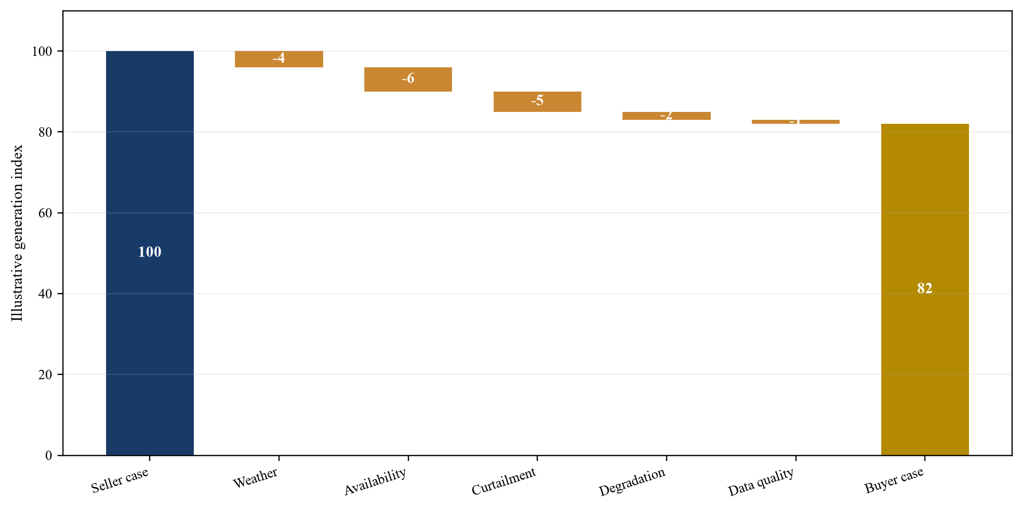
Management assumptions separate weather, availability, curtailment, degradation and data-quality effects. Values do not represent observed project performance.
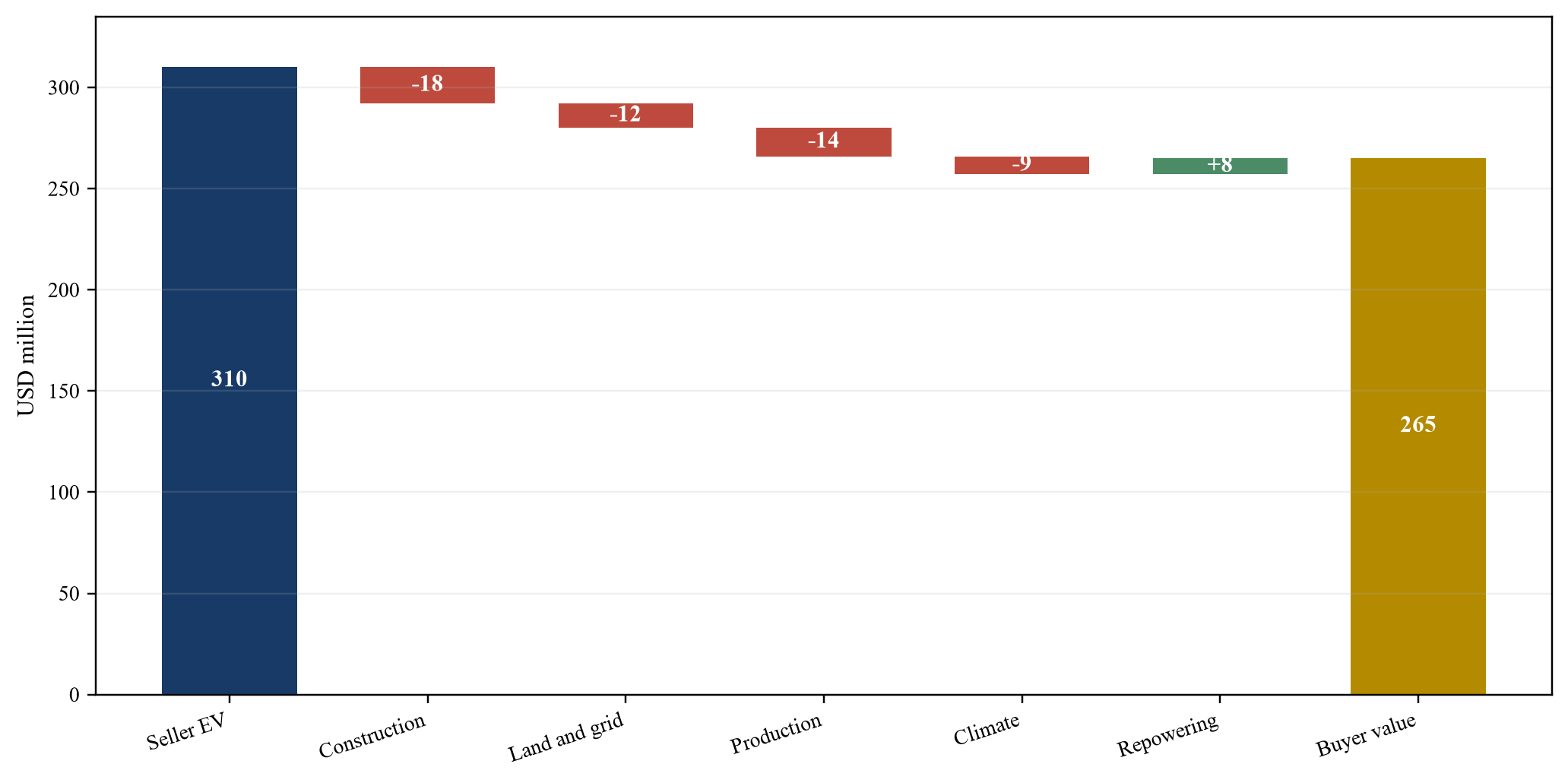
Management assumptions bridge seller headline enterprise value to evidence-weighted buyer value. The figure is illustrative and does not represent a valuation.
| Item | USD million | Evidence basis | Proposed treatment |
|---|---|---|---|
| Seller headline enterprise value | 310 | Seller management case | Starting point only |
| Construction and remaining capital | -18 | Milestone and capex exceptions | Price adjustment or holdback |
| Land and interconnection | -12 | Rights and connection gaps | Condition, exclusion or escrow |
| Production and curtailment | -14 | Rebuilt operating bridge | Cash-flow adjustment |
| Climate and insurance | -9 | Hazard, coverage and downtime case | Reserve and value adjustment |
| Repowering optionality | 8 | Rights and grid headroom assumed verified | Separate option value |
| Evidence-weighted buyer value | 265 | Management assumptions | Approval case |
| Cash at closing | 245 | Hypothetical structure | Funded consideration |
| Contingent consideration | 20 | Defined post-signing milestones | Pay only on verified achievement |
Management assumptions in USD million. The table is illustrative and does not represent a valuation or committed financing.
25. Carry diligence into integration and monitoring
The acquisition evidence base should become the opening asset register for integration. Unresolved issues need owners, budgets, deadlines and escalation rules. Land, permit, grid, operating, climate and environmental evidence should reconcile with finance systems and board reporting. A separate diligence archive that is never connected to operations loses much of its value.
Post-close satellite monitoring can test visible construction, land change, flood, vegetation, access and selected operating anomalies. Monitoring frequency should follow the risk and the practical resolution of the data. Alerts should trigger investigation rather than automatic financial action. Field evidence, operator records and legal review remain necessary.
The buyer should measure whether exceptions close and whether the acquisition case remains valid. Production, curtailment, availability, capex, insurance and community commitments should be tracked against the approved case. Model errors should be attributed to data, assumption, execution or external change. Lessons should update the next acquisition without rewriting the original approval record.
26. Govern AI and automated change detection
Automated classification can help compare many sites and dates, but it introduces model risk. Training data may come from different climates, technologies or construction patterns. Cloud, haze, seasonal agriculture, shadows, water and resolution can create false signals. The buyer should validate the model on representative sites and periods and should preserve human review for material decisions.
The governance record should state the model purpose, approved inputs, validation standard, confidence threshold, override process, monitoring and retirement rule. Material features should be explainable to the investment committee and technical advisers. If a score cannot be traced to observable inputs and validation evidence, it should not control price or contractual rights.
Data access and security also matter. Asset coordinates, grid infrastructure and operating data may be sensitive. The team should apply role-based access, retention limits, secure transfer and vendor diligence. Model providers should disclose relevant data use, subcontracting and intellectual-property terms. The acquisition should not create a new uncontrolled data dependency.
27. Execute an investment-committee evidence register
The final investment paper should present the frozen perimeter, value by cohort, material exceptions, downside cases, contractual protections, financing and integration obligations. Every material finding should link to evidence and a decision. The committee should be able to identify which assets support value at closing, which value remains contingent and which risks have been retained.
The evidence register should include source, observation, interpretation, corroboration, confidence, materiality, owner, status, model impact and contractual response. It should preserve disagreements between advisers and explain the approved judgement. A clean summary should not erase uncertainty that still affects the decision.
Reject criteria should be explicit. Examples include inability to establish ownership or transfer, invalid land or grid rights, material unremedied environmental harm, unaffordable remaining capital, structurally impaired revenue, or evidence manipulation. The framework supports a faster decision because it directs work to the facts that can change price, terms or approval.
28. Conclude with an evidence-to-value discipline
Satellite diligence can make distributed renewable acquisitions more transparent and more efficient. Its contribution is strongest where the portfolio is physically dispersed, documentation is inconsistent and the buyer needs an independent chronology. It creates a common spatial view across legal, technical, commercial, environmental and financial workstreams.
The method has a clear boundary. Satellite data observes selected physical characteristics. It does not establish legal rights, contractual cash flow, safety, compliance or value by itself. Every material observation should therefore lead to corroboration, a model consequence, a contractual response or a post-close control. Observations that cannot meet this test should remain contextual rather than decisive.
Southeast Asia's renewable buildout and investment needs make platform transactions increasingly important [1-3,25]. The quality of those transactions will depend on country-specific evidence, disciplined capital allocation and credible operating plans. A buyer that combines satellite chronology with field, contract and cash-flow evidence can identify where value is real, where it remains conditional and where the appropriate decision is to reprice, restructure or walk away.
Sources
- International Energy Agency, Southeast Asia Energy Outlook 2026: Energy in Southeast Asia. Read the primary source
- International Energy Agency, World Energy Investment 2024: Southeast Asia. Read the primary source
- International Energy Agency, ASEAN Renewables Investment: Opportunities and Challenges, 2023. Read the primary source
- International Energy Agency, Financing the ASEAN Power Grid: Executive Summary. Read the primary source
- Asian Development Bank, Accelerating Indonesia's Clean Energy Transition, 2025. Read the primary source
- Asian Development Bank, ASEAN Catalytic Green Finance Facility 2025. Read the primary source
- ASEAN Taxonomy Board, ASEAN Taxonomy for Sustainable Finance Version 4, 2026. Read the primary source
- ASEAN Taxonomy Board, ASEAN Taxonomy for Sustainable Finance Version 3, 2024. Read the primary source
- International Renewable Energy Agency, The Cost of Financing for Renewable Power, 2023. Read the primary source
- International Renewable Energy Agency, Renewable Energy Outlook for ASEAN, 2022. Read the primary source
- Copernicus Data Space Ecosystem, Sentinel-2 Data Collection. Read the primary source
- European Space Agency, Sentinel-2 User Handbook. Read the primary source
- European Space Agency, Sentinel-1 Brings Radar Remote Sensing to a New Level. Read the primary source
- United States Geological Survey, Earth Resources Observation and Science Center. Read the primary source
- United States Geological Survey, Tracking Change Across Time and Space. Read the primary source
- World Bank and ESMAP, Global Solar Atlas 2.0 Technical Report. Read the primary source
- World Bank and ESMAP, Vietnam Solar Mapping Site Selection Report. Read the primary source
- International Finance Corporation, Performance Standards on Environmental and Social Sustainability. Read the primary source
- International Finance Corporation, Good Practice Handbook: Land Acquisition and Involuntary Resettlement, 2023. Read the primary source
- Philippines Department of Energy, Ten-Year Green Energy Auction Plan, 2026. Read the primary source
- PT PLN, Electricity Supply Business Plan 2025-2034. Read the primary source
- Viet Nam Ministry of Industry and Trade, Implementation of the Adjusted Power Development Plan VIII, 2026. Read the primary source
- Sustainable Energy Development Authority Malaysia, Malaysia Renewable Energy Roadmap. Read the primary source
- Sustainable Energy Development Authority Malaysia, Net Energy Metering 3.0. Read the primary source
- International Energy Agency, High Cost of Capital and Limited Project Pipeline Hinder Clean Energy Investment in Southeast Asia, 2025. Read the primary source
- International Renewable Energy Agency, Renewable Power Generation Costs in 2024. Read the primary source
